


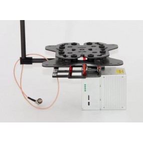
| Name: | GNSS/INS Hardware | Application 1: | Positioning And Altitude |
|---|---|---|---|
| Application 2: | Velocity Measurement | Function: | Trajectory Process |
| High Light: |
Positioning And Altitude Determination SystemGNSS INS Altitude Determination SystemAltitude gnss ins system |
||
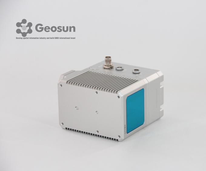
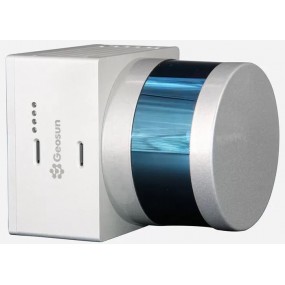
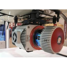
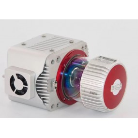
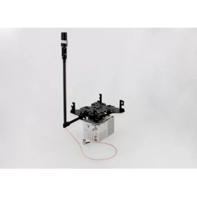
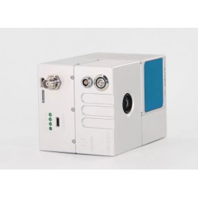
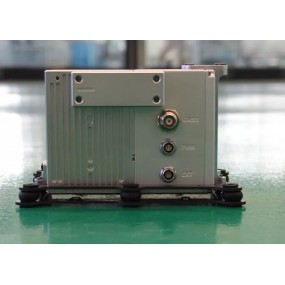
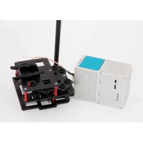
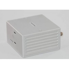
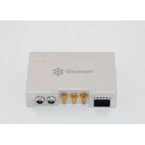
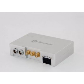
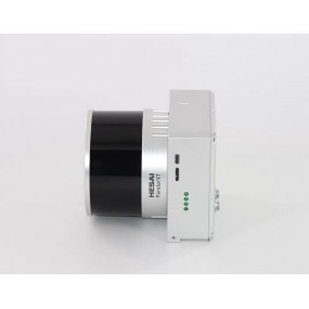
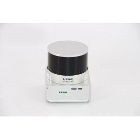
Positioning and Altitude Determination System
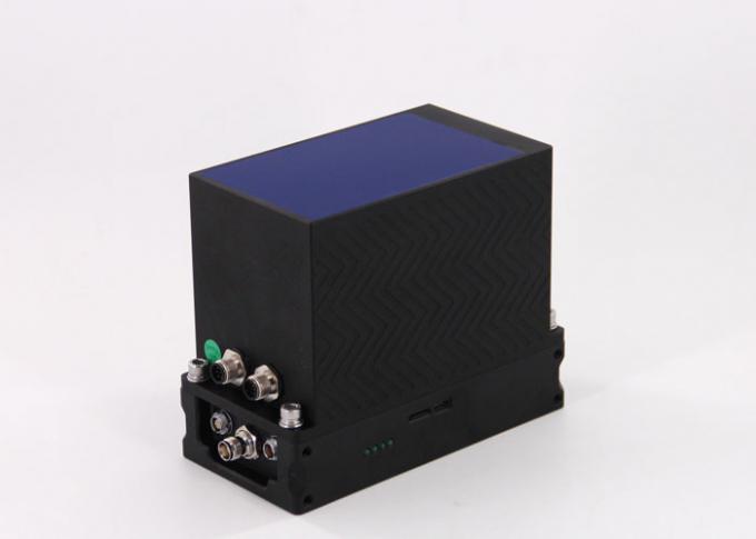
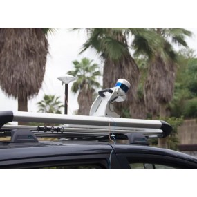
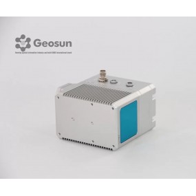
AGS 302 (301/303) adds a high-precision inertial navigation (IMU) module, no matter how the fuselage tilts during the aviation flight, it can accurately provide position, velocity and 3D attitude information.
After the data processing of professional software, AGS 302 (301/303) provides threedimensional position accuracy of 0.05 m, velocity of 0.02 m/s, heading of 0.040 degree, and pitch/roll of 0.015 degree, data sampling rate ups to 200Hz. With AGS 302 (301/303), UAV Aerial remote sensing can completely be free from ground control point, it is especially applied to the UAV surveying in strip area, irregular shape area, large watershed area and high latitude area; and is also widely used in UAV laser scanning and other direct geo-reference aerial remote sensing fields. For the users who required high-precision and real-time in precision agriculture, electricity and other areas, AGS 302 (301/303) also offers GNSS real-time differential positioning (RTK) function.
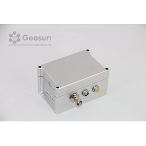
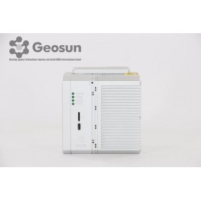
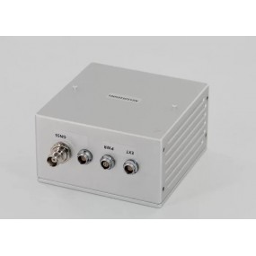
It supports UHF radio and 3G communication module, can receive real-time base station differential data. The UHF is compatible with PCC, Trimtalk, SATEL communication protocol, and working range ups to 5 km. AGS AGS 302 (301/303) adopts metallic cover, which makes the device lighter and more stable in signal reception, the designation fully considered the performance of waterproof, shockproof and dustproof.
AGS 302 (301/303) supports a variety of aerial triangulation software, including Pix4D, UAV Master, PhotoScan, Smart3D, GodWork, SVS, SkyPhoto, etc., Furthermore, it is applicable to a variety of branded UAV, and is also compatible with all commercial flight control systems.
Specification
| POS Unit 301 | Update frequency | 200HZ |
| Heading accuracy | 0.080° | |
| Pitch accuracy | 0.025° | |
| Rolling accuracy | 0.025° | |
| Position accuracy | ≤0.05m | |
| GNSS signal type | GPSL1/L2 GLONASSL1/L2 BDS B1/B2a/B3 | |
| GNSS Motherboard | Unicorecomm | |
| POS Type | AGS 301 |
| POS Unit 302 | Update frequency | 200HZ |
| Heading accuracy | 0.040° | |
| Pitch accuracy | 0.015° | |
| Rolling accuracy | 0.015° | |
| Position accuracy | ≤0.05m | |
| GNSS signal type | GPSL1/L2 GLONASSL1/L2 BDS B1/B2a/B3 | |
| GNSS Motherboard | OEM 719 | |
| POS Type | AGS 302 |
| POS Unit 303 | Update frequency | 200HZ |
| Heading accuracy | 0.017° | |
| Pitch accuracy | 0.005° | |
| Rolling accuracy | 0.005° | |
| Position accuracy | ≤0.05m | |
| GNSS signal type | GPSL1/L2 GLONASSL1/L2 BDS B1/B2a/B3 | |
| GNSS Motherboard | OEM 719 | |
| POS Type | AGS 303 |
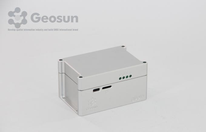
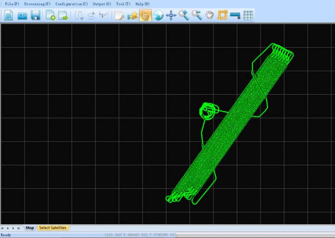
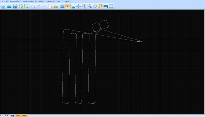
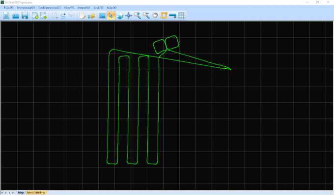
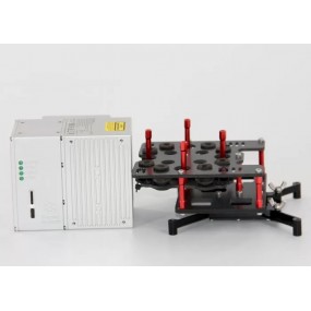
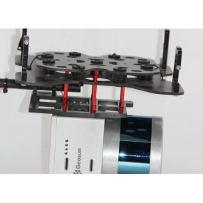
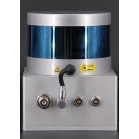
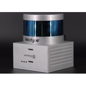
Integration LiDAR System
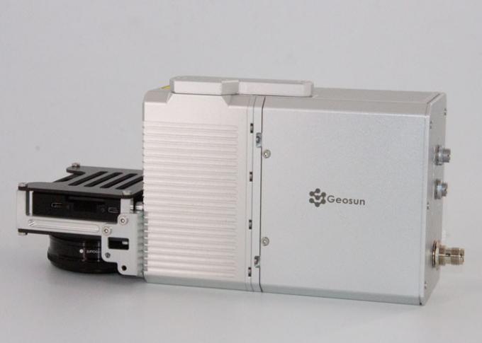
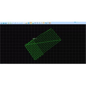
Application for POS Data Post Processing
16 other products in the same category:
gAirHawk GS-100M+ LIDAR SCANNING SYSTEM UAV LiDAR Scanning System with Triple Echo Livox Avia Laser SensorgAirHawk GS-100M+ is a kind of light compact LiDAR point cloud data acquisition system,...

gAirHawk GS-260F UAV LIDAR SCANNING SYSTEM Drone LiDAR Scanning System Application for Mapping and Survey gAirHawk GS-260F is a kind of Mid-range, compact LiDAR point cloud data acquisition system,...
GNSS/INS System Integrated Laser Sensors AGS 302 (301/303) adds a high-precision inertial navigation (IMU) module, no matter how the fuselage tilts during the aviation flight, it can accurately...
GGPoS is a high accuracy GPS/GLONASS/BDS/Galileo positioning and velocity determination software system, which can process measured data of single-frequency /double-frequency...
gAirHawk GS-100V LIDAR SCANNING SYSTEM Mobile LiDAR Scanning System with Velodyne Scanner gAirHawk GS-100V is a kind of short range, compact LiDAR point cloud data acquisition system, integrated...

gAirHawk GS-130H UAV LIDAR SCANNING SYSTEM UAV LiDAR Scanning System with Livox Horizon Laser Sensor gAirHawk GS-130H New Designed is a kind of short range, compact LiDAR point cloud data...
gAirHawk GS-1350 UAV LIDAR SCANNING SYSTEM UAV LiDAR Scanning System with Long Range Riegl Sensor gAirHawk GS-1350 is a kind of long range, compact LiDAR point cloud data acquisition system,...
gAirHawk Introduction 3D LiDAR Data Processing Software With Color PT File OutputgAirHawk is a lidar scanning system acquisition monitoring and point cloud computing software self-developed by...
gAirHawk GS-100C+ LIDAR SCANNING SYSTEM Drone LiDAR Scanning System Mounted on DJI Drone with Livox Avia Laser Sensor and Build-in CameragAirHawk GS-100C+ is a kind of light compact LiDAR point...
gAirHawk GS-260P LIDAR SCANNING SYSTEM Drone LiDAR Scanning System mounted on DJI M300 with 3D data collectiongAirHawk GS-260P is a kind of light compact LiDAR point cloud data acquisition system,...
GNSS/INS System Integrated Laser Sensors AGS 301 (302/303) adds a high-precision inertial navigation (IMU) module, no matter how the fuselage tilts during the aviation flight, it can accurately...
gAirHawk GS-100V UAV LIDAR SCANNING SYSTEM Uav LiDAR Scanning System with 3D Spatial Data Collecting Velodnye Laser Sensor gAirHawk GS-100V is a kind of short range, compact LiDAR point cloud data...
GNSS/INS System with 3D Data Collector AGS 300 adds a high-precision inertial navigation (IMU) module, no matter how the fuselage tilts during the aviation flight, it can accurately provide...
Shuttle Software with Independent Property Right Shuttle Software with Trajectory Process , GNSS/INS Software Shuttle is a high-precision GNSS/INS positioning and attitude determination...
gAirHawk GS-260X UAV LIDAR SCANNING SYSTEM LiDAR Scanning System Application for 3D Surveying and Mapping gAirHawk GS-260X is a kind of Mid-range, compact LiDAR point cloud data acquisition system,...
| Name: | GNSS/INS Hardware | Application 1: | Positioning And Altitude |
|---|---|---|---|
| Application 2: | Velocity Measurement | Function: | Trajectory Process |
| High Light: |
Positioning And Altitude Determination SystemGNSS INS Altitude Determination SystemAltitude gnss ins system |
||

error Your review appreciation cannot be sent